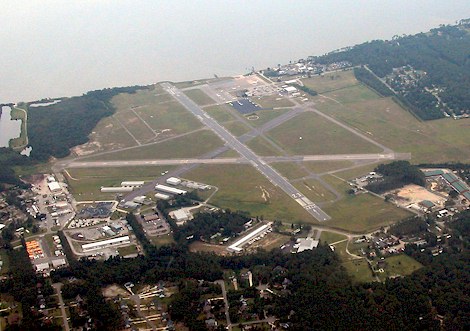
APA -
Centennial,
Denver, CO
Any information displayed may not be accurate or current and should not be considered valid for navigation, flight planning, or for use in flight. Please consult official publications for current and correct information.
|
|
Location:
FAA Identifier:
|
APA |
Latitude/Longitude:
|
39-34-12.4602N / 104-50-57.5000W 39.57 / -104.8491
|
Elevation:
|
5885 feet MSL (Surveyed) |
Magnetic Variation:
|
08E (2015)
|
Land Area Covered:
|
1400 acres
|
From City:
|
15 nautical miles SE of Denver, CO
|
County/Parish:
|
Arapahoe, CO
|
 |
|
|
Airport Operations:
Airport Use:
|
Public
|
Activiation Date:
|
3/1/1968 12:00:00 AM
|
Sectional Chart:
|
Denver
|
Control Tower:
|
Yes
|
ARTCC:
|
Denver Center (ZDV)
|
FSS:
|
Denver Flight Service Station ()
|
Attendance:
|
Continuous
|
Wind Indicator:
|
Yes - Lighted
|
Segmented Circle:
|
No
|
Lights:
|
Ss-Sr
|
Beacon:
|
White-Green (lighted land airport)
|
International Operations:
|
No
|
Landing Fee:
|
No
|
 |
|
|
Communications:
Unicom:
|
122.95 |
LCL/P
|
118.9 |
GND/P
|
121.8 |
CD/P
|
128.6 |
ATIS
|
120.3 |
FREQ 121.5 NOT AVBL. |
ADVISE GROUND CONTROL WHEN READY FOR DEPARTURE. GROUND CONTROL WILL ADVISE WHEN TO MONITOR THE TOWER FREQUENCY. |
DENVER RCO 122.35 122.2 (DENVER RADIO) |
 |
|
|
Services:
Fuel available:
|
100LL Jet-A |
Airframe Repair:
|
Major |
Power Plant Repair:
|
Major |
Bulk oxygen:
|
High/low |
 |
|
|
Runway Information:
Runway: |
10/28 |
Dimensions:
|
4800 x 75 ft. |
Surface:
|
Asphalt - in good condition |
Surface Treatment:
|
Saw-cut or plastic groove |
Weight Bearing Capacity:
|
Single wheel: |
12.5 K lbs. |
|
Runway Edge Lights:
|
Medium intensity |
 |
|
 |
Runway 10 |
 |
Runway 28 |
Latitude: |
39-34-22.4200N |
Latitude: |
39-34-05.4605N |
Longitude: |
104-50-53.5700W |
Longitude: |
104-49-56.3500W |
Elevation: |
5824 ft. |
Elevation: |
5794 ft. |
Gradient: |
0.6% |
Gradient: |
0.6% |
Traffic Pattern: |
Left |
Traffic Pattern: |
Left |
Displaced Threshold: |
400 ft. |
Displaced Threshold: |
No |
Markings: |
NPI - Non-precision instrument, Good condition |
Markings: |
NPI - Non-precision instrument, Good condition |
Visual Glide Angle: |
3° |
Visual Glide Angle: |
3° |
Runway End Identifier Lights: |
|
Runway End Identifier Lights: |
Yes |
 |
|
 |
|
Runway: |
17L/35R |
Dimensions:
|
10000 x 100 ft. |
Surface:
|
Asphalt - in good condition |
Surface Treatment:
|
Saw-cut or plastic groove |
Weight Bearing Capacity:
|
Single wheel: |
56 K lbs. |
Double wheel: |
75 K lbs. |
|
Runway Edge Lights:
|
Medium intensity |
 |
|
 |
Runway 17L |
 |
Runway 35R |
Latitude: |
39-35-02.9100N |
Latitude: |
39-33-24.1500N |
Longitude: |
104-51-05.3100W |
Longitude: |
104-51-00.7600W |
Elevation: |
5793 ft. |
Elevation: |
5885 ft. |
Gradient: |
0.9% |
Gradient: |
0.9% |
Traffic Pattern: |
Left |
Traffic Pattern: |
Right |
Displaced Threshold: |
No |
Displaced Threshold: |
No |
Markings: |
PIR - Precision instrument, Good condition |
Markings: |
PIR - Precision instrument, Good condition |
Visual Glide Angle: |
3° |
Visual Glide Angle: |
3° |
Approach Lights: |
|
Approach Lights: |
MALSR |
 |
|
 |
|
Runway: |
17R/35L |
Dimensions:
|
7001 x 75 ft. |
Surface:
|
Asphalt - in good condition |
Surface Treatment:
|
Saw-cut or plastic groove |
Weight Bearing Capacity:
|
|
Runway Edge Lights:
|
Medium intensity |
 |
|
 |
Runway 17R |
 |
Runway 35L |
Latitude: |
39-34-44.3495N |
Latitude: |
39-33-35.2264N |
Longitude: |
104-51-13.3876W |
Longitude: |
104-51-10.1904W |
Elevation: |
5804 ft. |
Elevation: |
5869 ft. |
Gradient: |
0.9% |
Gradient: |
1% |
Traffic Pattern: |
Right |
Traffic Pattern: |
Left |
Displaced Threshold: |
No |
Displaced Threshold: |
No |
Markings: |
NPI - Non-precision instrument, Good condition |
Markings: |
NPI - Non-precision instrument, Good condition |
Visual Glide Angle: |
3° |
Visual Glide Angle: |
3° |
Runway End Identifier Lights: |
Yes |
Runway End Identifier Lights: |
Yes |
 |
|
 |
|
|
Airport Ownership and Management:
Ownership:
|
Publicly Owned |
Owner:
|
Arapahoe Co Public Arpt Auth 7800 S Peoria St Englewood, CO 80112 303-790-0598
|
Manager:
|
Robert Olislagers 7800 South Peoria St Englewood, CO 80112 303-790-0598
|
 |
|
|
Remarks:
- ALL ACFT BLO CERTIFICATED 70000 LB MAX GROSS TKOF WT & STAGE III ACFT UP TO CERTIFICATED 75000 LB MAX GROSS TKOF WT MAY BE OPERATED; ONE-TIME EXCEPTIONS MAY BE AUZD BY EXEC DIR ON A CASE-BY-CASE BASIS.
- NUMEROUS FLOOD LGTS LCTD 1/2 SM N OF THLD RY 17L SS-2400.
- HELICOPTER OPS PLEASE CONTACT PREFERRED FBO FOR LANDING ZONE LOCATIONS. HELICOPTER OPS ON FRONT RAMP NOT ADVISED.
- 24 HR. USER FEE CUSTOMS AVAILABLE. CONTACT AIRPORT FOR FEE INFORMATION.
- NOISE ABATEMENT PROCEDURES IN EFFECT; CTC NOISE OFFICE 303-790-0598.
- ADVISORY DENSITY ALTITUDE DISPLAYS LOCATED AT C-1,A-1, AND A-18.
- TWY S2 CLSD INDEFINATELY
- WATERFOWL ON & INVOF ARPT.
- NMRS CRANES INVOF ARPT.
- +190 FT TWR LCTD 1800 FT ENE OF RY 17L THLD.
- RY 35R-CROSSWIND/BASE LEG NORTH OF LINCOLN AVE RY 17L CROSSWIND/BASE LEG SOUTH OF ARAPAHOE ROAD. RY 17R/35L CLSD TFC REMAIN S OF ARAPAHOE ROAD & E OF INTERSTATE 25. RY 10/28 AVOID NOISE SENSITIVE AREAS 1 MILE E & S OF RY.
- AFT HRS PHONE (303) 877-7307.
- SELF SERVE 100LL FUEL AVBL.
- US CUSTOMS USER FEE ARPT.
- CALL US CUSTOMS 303-768-0309.
|
|
FunPlacesToFly.com and OpenAirNet Inc. shall not be held liable
for any financial loss, damages or injury due the use of, or reference
to the information displayed above. Always call ahead to
confirm any information listed and the existence of the destination.
Any information displayed may not be accurate or current and should
not be considered valid for navigation, flight planning, or for use in flight.
Please consult official publications for current and correct information.
Please read our Disclaimer.
|
|