
Aviation Events, Places to Fly and MORE!

Receive our Email Newsletters about upcoming Aviation Events, Great Places to Fly and Videos! Post our Flyer! Add Your Favorite Place to Fly!
Add Your Aviation Event!
Virgil I Grissom Municipal Airport
Virgil I Grissom Municipal Airport, wonderful place to stop and take in the surroundings. Spring Mill State Park is only 10 miles away and they have a courtesy car available for the asking. One of the friendliest and down to earth airports I've been to lately, it's nice to know that that an airport can still be just a nice place to stop in and say Hi. - Submitted by Steve
All destinations and events listed on this website were provided by visitors to our website. If you decide
to fly or drive to any destination listed, you do so at your own risk. Please see our disclaimer.
|
|
Amenities:  100LL
Hangars
Maintenance
Tiedowns 100LL
Hangars
Maintenance
Tiedowns
|
Contact Information:
Phone: 812-279-9839
Phone: 812-279-9839
Airport Information:
|
Virgil I Grissom Muni (BFR) Latitude: 38-50-24.1000N |
|
|
Location:
|
3213 Tunnelton Rd Bedford, IN |
Comments and Reviews From FunPlacesToFly.com Visitors:
Write a review, suggest updates or make comments!
Write a review, suggest updates or make comments!
- No reviews so far
FunPlacesToFly.com is an Amazon Associate. As an Amazon Associate we earn from qualifying purchases.


Nearby Public Airports: (50 mile radius)
|
Photos:
All photos shown below are provided/uploaded by visitors to our website, which have agreed to our Photo Submission Rules.
Got a photo?, share it with us
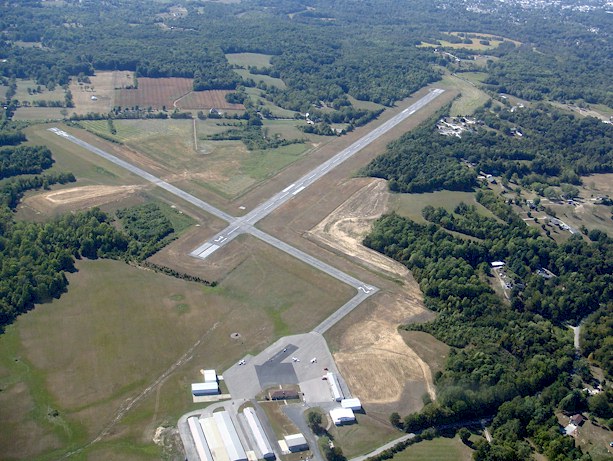
KBFR from pattern altitude departing to the north. - Uploaded by Steve Edmonds
All photos shown below are provided/uploaded by visitors to our website, which have agreed to our Photo Submission Rules.
Got a photo?, share it with us
KBFR from pattern altitude departing to the north. - Uploaded by Steve Edmonds

Advertise with us!
 |
 |
 |
 |
 |
 |
 |
 |
 |
 |
 |
 |
 |