Aviation Events, Places to Fly and MORE!

Butter Valley Golf Port, Bally, PA (7N8)

Search More Places to Fly:
Your Airport ID:
* OR *
Your Zip Code:
Range (miles):

How far is that Airport?
Distance Calculator!

Aviation Events Calendar
Receive our Email Newsletters about upcoming Aviation Events, Great Places to Fly and Videos! Post our Flyer!
Add Your Favorite Place to Fly!
Add Your Aviation Event!

Butter Valley Golf Port

Located in rural Berks County, PA Butter Valley Golf Port is a unique flying destination. Runway 34 is 1,535' X 24' and paved. Rwy 16 is a 2,420' X 85' turf. Take off and landings are right through the middle of the 18 hole golf course. Bring your clubs and make a day of it! - Submitted by rcressman
All destinations and events listed on this website were provided by visitors to our website. If you decide to fly or drive to any destination listed, you do so at your own risk. Please see our disclaimer.

Video Created by Dave Fisher


Amenities:
Hangars Tiedowns
How far away is Butter Valley Golf Port?
From Airport ID:
To Airport ID:
Mileage Type:
Visit this Website:
https://buttervalley.com/airport/
Contact Information:
Email: viplist-mail@buttervalley.com
Phone: 610-845-2491
Airport Information:
Butter Valley Golf Port (7N8)

More info from AirNav.com

Latitude: 40-23-53.3520N
Longitude: 075-33-51.6610W
Elevation: 500
Fuel:
CTAF: 122.8
Unicom:

Try Our Trip Calculator!


See it on a Large Google Map!

Location:
South 7th Street
Bally, PA
Comments and Reviews From FunPlacesToFly.com Visitors:
Write a review, suggest updates or make comments!

9/7/2020 - The restaurant is currently closed. - Submitted by Joe Bowers

11/21/2019 - Butter Valley restaurant is CLOSED. No longer serving meals. - Submitted by Rod

5/9/2013 - My favorite place for breakfast. Very economical. The runway will challenge your skills! - Submitted by Frank
FunPlacesToFly.com is an Amazon Associate. As an Amazon Associate we earn from qualifying purchases.
Nearby Public Airports: (50 mile radius)
ID Name City/State/Use Chart Name Distance
UKT Quakertown Quakertown, PA
Public
New York 10 miles
PTW Heritage Field Pottstown, PA
Public
New York 11 miles
N47 Pottstown Muni Pottstown, PA
Public
New York 11 miles
XLL Allentown Queen City Muni Allentown, PA
Public
New York 13 miles
CKZ Pennridge Perkasie, PA
Public
New York 14 miles
N10 Perkiomen Valley Collegeville, PA
Public
New York 15 miles
ABE Lehigh Valley Intl Allentown, PA
Public
New York 19 miles
RDG Reading Rgnl/carl A Spaatz Field Reading, PA
Public
New York 21 miles
O03 Morgantown Morgantown, PA
Public
New York 23 miles
DYL Doylestown Doylestown, PA
Public
New York 24 miles
LOM Wings Field Philadelphia, PA
Public
New York 24 miles
P91 Flying M Aerodrome Germansville, PA
Public
New York 25 miles
9N1 Vansant Erwinna, PA
Public
New York 25 miles
69N Slatington Slatington, PA
Public
New York 25 miles
OQN Brandywine West Chester, PA
Public
Washington 28 miles
N43 Braden Airpark Easton, PA
Public
New York 29 miles
22N Jake Arner Memorial Lehighton, PA
Public
New York 30 miles
14N Beltzville Lehighton, PA
Public
New York 31 miles
N85 Alexandria Pittstown, NJ
Public
New York 31 miles
N40 Sky Manor Pittstown, NJ
Public
New York 33 miles
MQS Chester County G O Carlson Coatesville, PA
Public
Washington 33 miles
PNE Northeast Philadelphia Philadelphia, PA
Public
New York 36 miles
8N1 Grimes Bethel, PA
Public
New York 37 miles
PHL Philadelphia Intl Philadelphia, PA
Public
Washington 40 miles
9D4 Deck Myerstown, PA
Public
New York 40 miles
TTN Trenton Mercer Trenton, NJ
Public
New York 40 miles
N57 New Garden Toughkenamon, PA
Public
Washington 41 miles
08N Keller Brothers Lebanon, PA
Public
New York 41 miles
S37 Smoketown Smoketown, PA
Public
New York 42 miles
LNS Lancaster Lancaster, PA
Public
New York 43 miles
N51 Solberg-Hunterdon Readington, NJ
Public
New York 45 miles
9N7 Farmers Pride Fredericksburg, PA
Public
New York 46 miles
HZL Hazleton Rgnl Hazleton, PA
Public
New York 47 miles
7N7 Spitfire Aerodrome Pedricktown, NJ
Public
Washington 47 miles
N05 Hackettstown Hackettstown, NJ
Public
New York 47 miles
ZER Schuylkill County /joe Zerbey Pottsville, PA
Public
New York 48 miles
39N Princeton Princeton/rocky Hill, NJ
Public
New York 48 miles
N53 Stroudsburg-Pocono East Stroudsburg, PA
Public
New York 49 miles
VAY South Jersey Rgnl Mount Holly, NJ
Public
Washington 49 miles
1N7 Blairstown Blairstown, NJ
Public
New York 49 miles
SMQ Somerset Somerville, NJ
Public
New York 50 miles
ILG New Castle Wilmington, DE
Public
Washington 50 miles
Photos:
All photos shown below are provided/uploaded by visitors to our website, which have agreed to our Photo Submission Rules.
Got a photo?, share it with us


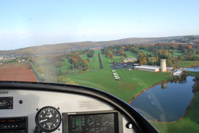
Fall 2012 on final to Butter Valley Golf Port - Uploaded by David Valcik

Fun Places to Fly Search:
Your Airport ID:
* OR *
Your Zip Code:
Range (miles):
Airport Search:
ID, Name
or City:
State:
Airport Distance Calculator:
From Airport ID:
To Airport ID:
Mileage Type:
Put this on your Website!

FunPlacesToFly.com is owned and maintained by OpenAirNet Inc. All rights reserved. WrapBootStrap.com Licensed Website. For more information, contact us.

OpenAirNet Incorporated and FunPlacesToFly.com. Unauthorized use and/or duplication of this material without express and written permission from this site's author and/or owner is strictly prohibited. Excerpts and links may be used, provided that full and clear credit is given to OpenAirNet Incorporated and FunPlacesToFly.com with appropriate and specific direction to the original content.