
Fun Places to Fly, Aviation Jobs and More!


Winkler County Airport
Wink, Texas Home of Roy Orbison. Wink is the perfect Food-Fuel-Rest Stop for East-West Southern Route Traffic. Located 68sm West of Midland and 196sm East of El Paso. Class E Airspace. Easy to fly in and get out quickly. 24 hr. weather observations. - Submitted by newslinknet
All destinations and events listed on this website were provided by visitors to our website. If you decide
to fly or drive to any destination listed, you do so at your own risk. Please see our disclaimer.
|

Contact Information:
Phone: 915-527-3481
Phone: 915-527-3481
Airport Information:
|
Winkler County (INK) Latitude: 31-46-47.3000N |
|
|
Location:
|
Wink, TX |
Comments and Reviews From FunPlacesToFly.com Visitors:
Write a review, suggest updates or make comments!
Write a review, suggest updates or make comments!
- No reviews so far
Nearby Public Airports: (50 mile radius)
|
Photos:
All photos shown below are provided/uploaded by visitors to our website, which have agreed to our Photo Submission Rules.
Got a photo?, share it with us
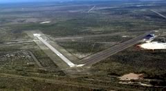
Winkler County Airport - Uploaded by Mike
All photos shown below are provided/uploaded by visitors to our website, which have agreed to our Photo Submission Rules.
Got a photo?, share it with us
Winkler County Airport - Uploaded by Mike
FunPlacesToFly.com is an Amazon Associate. As an Amazon Associate we earn from qualifying purchases.


Advertise with us!
 |
 |
 |
 |
 |
 |
 |
 |
 |
 |
 |
 |