Aviation Events, Places to Fly and MORE!

Westfield Airport I72, Westfield, IN (I72)

Search More Places to Fly:
Your Airport ID:
* OR *
Your Zip Code:
Range (miles):

How far is that Airport?
Distance Calculator!

Aviation Events Calendar
Receive our Email Newsletters about upcoming Aviation Events, Great Places to Fly and Videos! Post our Flyer!
Add Your Favorite Place to Fly!
Add Your Aviation Event!

Westfield Airport I72

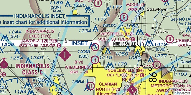
Westfield airport is a great place to fly in. There are courtesy bicycles there so you can hop on a bike and get to several restaurants and trails nearby. It is located just south of Grand Park in Westfield, IN where you are able to fly in and watch the kids play. Wide taxi way and a 3000' grass strip. This airport is home to the Indy-Flyers light sport club and is light sport and ultralight friendly. - Submitted by Monty Bolinger
All destinations and events listed on this website were provided by visitors to our website. If you decide to fly or drive to any destination listed, you do so at your own risk. Please see our disclaimer.

How far away is Westfield Airport I72?
From Airport ID:
To Airport ID:
Mileage Type:
Visit this Website:
http://www.westfieldairport.com/
Contact Information:
Phone: 317-846-6060
Airport Information:
Westfield (I72)

More info from AirNav.com

Latitude: 40-02-56.1350N
Longitude: 086-09-27.9630W
Elevation: 932
Fuel:
CTAF: 122.9
Unicom:

Try Our Trip Calculator!


See it on a Large Google Map!

Location:
18008 Dartown Rd
Westfield, IN
Comments and Reviews From FunPlacesToFly.com Visitors:
Write a review, suggest updates or make comments!
  • No reviews so far
FunPlacesToFly.com is an Amazon Associate. As an Amazon Associate we earn from qualifying purchases.
Nearby Public Airports: (50 mile radius)
ID Name City/State/Use Chart Name Distance
TYQ Indianapolis Executive Indianapolis, IN
Public
Chicago 5 miles
5I4 Sheridan Sheridan, IN
Public
Chicago 9 miles
UMP Indianapolis Metropolitan Indianapolis, IN
Public
St Louis 10 miles
I80 Noblesville Noblesville, IN
Public
Chicago 11 miles
6I4 Boone County Lebanon, IN
Public
Chicago 15 miles
EYE Eagle Creek Airpark Indianapolis, IN
Public
St Louis 17 miles
MQJ Indianapolis Rgnl Indianapolis, IN
Public
St Louis 20 miles
7L8 Post-Air Indianapolis, IN
Public
St Louis 22 miles
IND Indianapolis Intl Indianapolis, IN
Public
St Louis 24 miles
FKR Frankfort Muni Frankfort, IN
Public
Chicago 26 miles
8I3 Glenndale Kokomo, IN
Public
Chicago 27 miles
2R2 Hendricks County-Gordon Graham Fld Indianapolis, IN
Public
St Louis 27 miles
GFD Pope Field Greenfield, IN
Public
St Louis 29 miles
AID Anderson Muni-Darlington Field Anderson, IN
Public
Chicago 29 miles
HFY Indy South Greenwood Indianapolis, IN
Public
St Louis 29 miles
I99 Alexandria Alexandria, IN
Public
Chicago 30 miles
OKK Kokomo Muni Kokomo, IN
Public
Chicago 33 miles
GEZ Shelbyville Muni Shelbyville, IN
Public
St Louis 37 miles
5I6 Galveston Galveston, IN
Public
Chicago 37 miles
1I8 Converse Converse, IN
Public
Chicago 39 miles
MZZ Marion Muni Marion, IN
Public
Chicago 40 miles
5I2 Flora Muni Flora, IN
Public
Chicago 40 miles
CFJ Crawfordsville Muni Crawfordsville, IN
Public
St Louis 41 miles
GUS Grissom Arb Peru, IN
Public
Chicago 41 miles
MIE Delaware County Rgnl Muncie, IN
Public
Chicago 42 miles
3FK Franklin Flying Field Franklin, IN
Public
St Louis 43 miles
1I9 Delphi Muni Delphi, IN
Public
Chicago 44 miles
7I2 Reese Muncie, IN
Public
Chicago 45 miles
GPC Putnam County Rgnl Greencastle, IN
Public
St Louis 45 miles
UWL New Castle-Henry Co Muni New Castle, IN
Public
St Louis 46 miles
GGP Logansport/cass County Logansport, IN
Public
Chicago 47 miles
78I Pam'S Place Eminence, IN
Public
St Louis 47 miles
LAF Purdue University Lafayette, IN
Public
Chicago 48 miles
Photos:
All photos shown below are provided/uploaded by visitors to our website, which have agreed to our Photo Submission Rules.
Got a photo?, share it with us


Westfield Airport - Uploaded by Mike

Fun Places to Fly Search:
Your Airport ID:
* OR *
Your Zip Code:
Range (miles):
Airport Search:
ID, Name
or City:
State:
Airport Distance Calculator:
From Airport ID:
To Airport ID:
Mileage Type:
Put this on your Website!

FunPlacesToFly.com is owned and maintained by OpenAirNet Inc. All rights reserved. WrapBootStrap.com Licensed Website. For more information, contact us.

OpenAirNet Incorporated and FunPlacesToFly.com. Unauthorized use and/or duplication of this material without express and written permission from this site's author and/or owner is strictly prohibited. Excerpts and links may be used, provided that full and clear credit is given to OpenAirNet Incorporated and FunPlacesToFly.com with appropriate and specific direction to the original content.