
Aviation Events, Places to Fly and MORE!

Receive our Email Newsletters about upcoming Aviation Events, Great Places to Fly and Videos! Post our Flyer! Add Your Favorite Place to Fly!
Add Your Aviation Event!
Commemorative Air Force / Rio Grande Valley Wing

Visit the museum and take an exciting and educating tour through our Nation's WW-II history. Watch the events unfold, from the preludes to war in Asia and Europe to the fall of the Third Reich and the defeat of the Japanese Empire. - Submitted by Mike Smith
All destinations and events listed on this website were provided by visitors to our website. If you decide
to fly or drive to any destination listed, you do so at your own risk. Please see our disclaimer.
|
|
Amenities:  100LL
Hangars
JET-A
Maintenance
Oxygen
Tiedowns 100LL
Hangars
JET-A
Maintenance
Oxygen
Tiedowns
|
Contact Information:
Phone: (956)541-8585
Phone: (956)541-8585
Airport Information:
|
Brownsville/south Padre Island Intl (BRO) Latitude: 25-54-22.0873N |
|
|
Location:
|
955 South Minnesota Ave. Brownsville, TX |
Comments and Reviews From FunPlacesToFly.com Visitors:
Write a review, suggest updates or make comments!
Write a review, suggest updates or make comments!
- No reviews so far
FunPlacesToFly.com is an Amazon Associate. As an Amazon Associate we earn from qualifying purchases.


Nearby Public Airports: (50 mile radius)
|
Photos:
All photos shown below are provided/uploaded by visitors to our website, which have agreed to our Photo Submission Rules.
Got a photo?, share it with us

Rio Grande Valley Wing Website Logo - Uploaded by Ted
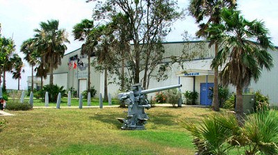
The Museum - Uploaded by Ted

The Barnstormers Lounge - Uploaded by Phil
All photos shown below are provided/uploaded by visitors to our website, which have agreed to our Photo Submission Rules.
Got a photo?, share it with us
Rio Grande Valley Wing Website Logo - Uploaded by Ted
The Museum - Uploaded by Ted
The Barnstormers Lounge - Uploaded by Phil

Advertise with us!
 |
 |
 |
 |
 |
 |
 |
 |
 |
 |
 |
 |
 |